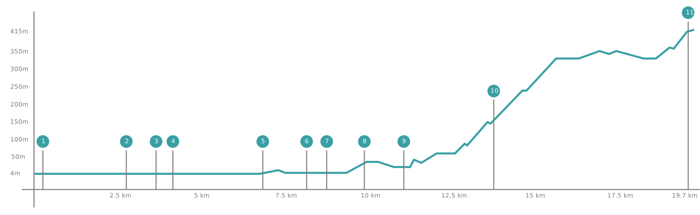
Percurso
Lima River to Serra de Arga Equestrian Trail


Points of interest
1. Parque Verde Lanheses
2. Embarcadouro de Fontão
3. Ponte Medieval
4. Solar e Pelourinho de Bertiandos
5. Ponte de Esteiro
6. Moinho do Matias
7. Ponte da Freixa e Rio Estorãos
8. Centro de Interpretação Ambiental da Área Protegida das Lagoas de Bertiandos e São Pedro de Arcos
9. Quinta dos Pentieiros
10. Serra do Formigoso / Castro e Castelo da Formiga
11. Cerquido
Lima River to Serra de Arga Equestrian Trail
The Lima River to Serra de Arga Equestrian Trail continues from the Ribeira Lima Walking and Equestrian Trail (PR25), which starts at the urban boundary of the city of Viana do Castelo.
This intermunicipal route offers an exhilarating experience of immersion in nature, taking in a diverse landscape mosaic and combining adventure, exploration and discovery of how this territory has evolved over time. Along the way, you will encounter traces of the Iron Age, Romanisation and medieval occupation, as well as the enduring legacy of manor houses, country estates and farmsteads inherited from the seigneurial landholding system, which survived well beyond the early modern period.
Starting amid the refreshing tranquillity of the banks of the River Lima, in the remarkable parish of Lanheses — once the seat of the municipality of Vila Nova de Lanheses between the late eighteenth and early nineteenth centuries — we invite you to take up the challenge of climbing to the secluded, authentic village of Cerquido, probably of Castro culture origin, on the southern slopes of the Serra de Arga. This mountain range is home to herds of Garrano ponies living in a semi-wild state.
Be captivated by breathtaking natural viewpoints overlooking the Estorãos River valley, with panoramic views stretching across the vast Lima alluvial plain and reaching the Atlantic coastline on the distant horizon. Observe the subtle, gradual transformation of the landscape as vegetation and land use change, with cultivated fields giving way to woodlands and forest plantations. Take note of the different signs of human presence across the territory, reflecting distinct ways of making a living: from the continuous yet scattered settlement pattern, dotted with manor houses, to the rural mountain hamlets, characterised by the imposing granite architecture of traditional buildings, raised granaries, threshing floors and irrigation channels. Discover the many points of interest dedicated to the area's natural and cultural heritage, each with a story to uncover or something new to learn.
The first section of this route is relatively flat and of low difficulty, running between Lanheses Green Park and the Bertiandos recreational area. It then continues along the alluvial plain on the right bank of the River Lima, passing traditional cultivated fields and vineyards.
In its final stretch, the Lima valley is bordered to the north and south by mountain ranges, rising in elevation from the Serra de Santa Luzia, which reaches 500 metres, to the Serra de Arga, whose plateau lies between 700 and 800 metres. The river flows through a broad, open valley with an extensive alluvial plain. This is the natural setting for the age-old, human-shaped landscape of Ribeira Lima. In this fertile floodplain, with its alluvial soils, intensive and long-established agricultural activity is embedded within a continuous, albeit dispersed and low-density, settlement pattern. The agricultural landscape, characterised by smallholdings and mixed farming, is marked by the widespread cultivation of maize and vines.
Following the right bank of the River Lima between Lanheses and Bertiandos, we travel through an important ecological corridor. The riverside woodland is fragmented, alternating with cultivated plots. Alder, ash, willow, silver birch and oak are among the most common tree species found along the riverbanks.
The route continues through the Bertiandos and São Pedro de Arcos Lagoons Protected Landscape Area. An unmissable experience is crossing on horseback the only designated wetland area in northern Portugal, a place of striking scenic beauty, formed predominantly by lake and estuarine environments. It supports a range of ecosystems, including wet woodlands, wet meadows, lagoons, rivers and pine forests. These habitats are of outstanding importance for biodiversity conservation, providing refuge, habitat and feeding grounds for a wide variety of animal and plant species.
The second section of the route contrasts sharply in terms of terrain and difficulty. The landscape becomes more rugged and the ride more demanding, owing to the considerable ascent of approximately 350 metres. It is therefore advisable to take a break to rest and replenish both horse and rider, making use of the equestrian tourist facilities and services available at Quinta de Pentieiros.
At the boundary of the parish of São Pedro de Arcos, the ascent begins along the western slope of Monte da Formiga. At its summit, at approximately 400 metres above sea level, once stood Formiga Castle, also known as Castro de Formigoso. This fortified settlement dates back to the Iron Age and was subsequently occupied by a medieval castle.
Once the steep summit has been reached and crossed, the route continues towards the village of Cerquido, where you can spend the night at accommodation establishments belonging to the 'Your Horse Is Our Guest' network ("O Seu Cavalo É Nosso Convidado").
From this final point, you can continue your equestrian journey of discovery by following the Serra de Arga Equestrian Trail, a circular route that encircles the entire mountain massif. Following rural and traditional livestock-grazing paths, it passes through the main mountain villages: Arga de Cima, Arga de Baixo, Arga de São João, Dem and, finally, Montaria, from where you can return to Cerquido.